Fueling Digital Transformation Across Sectors
Industries are increasingly adopting a powerful combination of technologies to drive digital transformation. The collaboration between unmanned aerial vehicles (UAVs), or drones, and mobile scanners is revolutionizing data collection and asset management. This synergy enables the creation of precise digital models, streamlines operations, and enhances safety across construction, logistics, and energy sectors. By working together, these tools provide a comprehensive view of complex environments, bridging the gap between aerial and ground-level data.
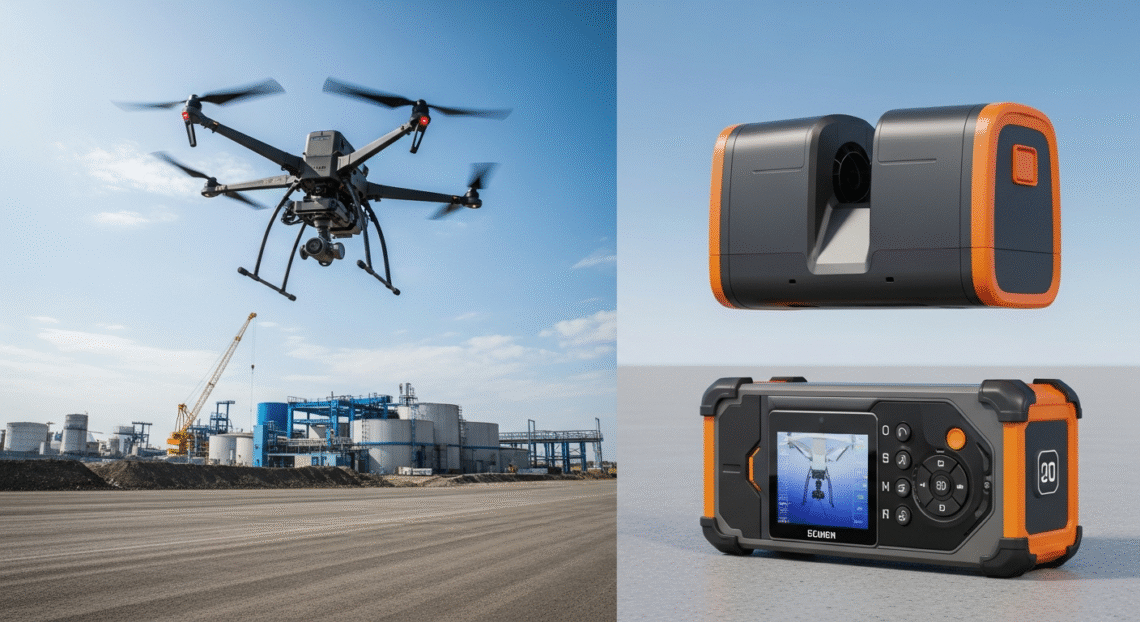
The core advantage lies in combining the strengths of each technology. Drones equipped with high-resolution cameras excel at capturing vast exterior areas quickly. Meanwhile, mobile scanners, often utilizing LiDAR technology, map intricate interior spaces with high accuracy. This combined approach is fundamental to building comprehensive digital twins—virtual replicas of physical assets.
A Case in Point: Digitizing a Major Transport Hub
A recent project to create a full digital twin of London’s King’s Cross Station showcases this collaboration in action. The primary goal was to build a detailed digital asset for a new asset management system. This initiative required a meticulous data capture strategy to model the entire station, both inside and out.
To achieve this, a UAV was deployed to conduct aerial surveys and gather high-resolution imagery of the station’s exterior. For the complex interiors, a mobile scanner was used to capture data with an accuracy of up to 6mm. Much of the scanning was performed at night to minimize disruption to station operations. Control points were established to ensure the data from both the drone and the scanner aligned perfectly, creating a single, unified 3D model. The final result was a complete digital replica, enabling improved operational efficiency and cost savings through reduced on-site inspections.
Expanding Applications in Diverse Industries
The partnership between drones and mobile scanning extends far beyond infrastructure projects. It provides significant benefits in public safety, industrial operations, and logistics automation, where efficiency and security are paramount.
Enhancing Public Safety and Industrial Operations
In public safety, the concept of a “Drone as a First Responder” (DFR) is gaining traction. Drones can be deployed ahead of emergency crews to provide critical situational awareness. This aerial intelligence helps teams assess an incident’s severity, allocate resources effectively, and improve the safety of personnel on the ground. When combined with advanced software, drones can automatically navigate complex environments and identify risks in real time.
This technology is equally transformative in critical industries like energy, mining, and manufacturing. Drones offer a safe and cost-effective way to inspect and monitor hazardous or remote sites, such as offshore platforms or vast utility networks. They can perform these tasks without putting workers in harm’s way, reducing the need for costly and carbon-intensive methods like helicopter inspections.
Revolutionizing Logistics and Warehouse Automation
Inventory management has long been a challenge in retail and logistics. Manual stock counts are time-consuming and prone to human error, leading to inaccuracies that affect the entire supply chain. The integration of drones and mobile scanning robots, often equipped with RFID technology, automates this process to achieve near-perfect inventory visibility.
Different tools play complementary roles in a modern warehouse.
- Fixed antennas track items at key chokepoints like entrances and exits.
- Drones quickly cover large areas and scan high shelving, ideal for periodic counts when a facility is empty.
- Autonomous mobile robots navigate aisles to provide continuous, ground-level inventory data safely alongside employees.
- Handheld scanners are used for targeted, specific checks.
This tiered approach ensures complete and frequent stock monitoring.
The Role of Advanced Connectivity
The full potential of this technological pairing is unlocked by advanced connectivity, particularly 5G networks. High-speed, low-latency communication is essential for streaming large volumes of data from drones and scanners in real time. This capability allows for immediate analysis and decision-making, which is critical for mission-sensitive applications.
Furthermore, 5G enables reliable Beyond Visual Line of Sight (BVLOS) operations, allowing drones to cover vast distances without a human operator nearby. In logistics and retail, this connectivity supports a seamless flow of information. While autonomous robots scan shelves, employees can use a barcode android scanner for specific tasks like order fulfillment and item registration, with all data synchronized instantly to a central system. This creates a cohesive and highly efficient asset management ecosystem.
By combining aerial drones with various ground-based mobile scanners, industries are building a more connected, intelligent, and automated future. This collaboration enhances data accuracy, improves worker safety, and drives operational efficiency, marking a significant step forward in industrial technology.